

The Aeon Herald / HISTORICAL EDITION
Cedar Fire Crosses the Distance Between Forest and City
An overnight run carried the Cedar fire from the Cleveland National Forest into San Diego. The final perimeter covers 273,246 acres; fifteen people died.
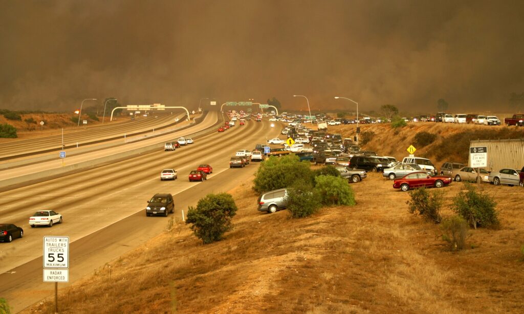
SAN DIEGO — In the space between an evening alarm and the next morning, the Cedar fire traversed a distance that had seemed to separate a forest emergency from a city emergency. The fire began October 25 in the Cleveland National Forest. By the following morning it had crossed the city boundary. The completed incident now encompasses 273,246 acres and 2,820 destroyed structures.
Fifteen people died. Fourteen were civilians; a firefighter died October 29 in the Julian area. Those deaths must remain at the center of an account otherwise crowded with spectacular dimensions. Acres describe the reach of the fire, and the building count describes one part of its destruction. Neither figure supplies a satisfactory measure of the human loss.
The early progression recorded by San Diego's fire department is extraordinary even without an adjective. At about 5:30 on Saturday afternoon the fire covered roughly twenty acres. At three o'clock Sunday morning it was 62,000. The fire entered San Diego at about 6:30 a.m. The night, rather than providing a reassuring interval before the next day's attack, became the period of catastrophic expansion.
Scripps Ranch and Tierrasanta suffered the city's heaviest losses. Within San Diego, the fire burned 28,676 acres, destroyed 335 structures and damaged seventy-one more. Those are city figures, a portion of a much larger incident whose perimeter included country beyond municipal protection lines. The same blaze had to be understood at the scale of a particular street, a city deployment and a national forest operation.
San Diego committed fifty engine companies, eleven brush rigs and nine trucks, along with two airport firefighting vehicles. Such a list is useful because it shows the breadth of the response. It also indicates the range of work required when a fast-moving landscape fire reaches buildings: engines defending structures, apparatus moving through threatened districts, and equipment suited to ground far removed from an ordinary hydrant-side assignment.
The wider picture was visible from space. NASA's Terra satellite passed over Southern California on October 26 and recorded several distinct groups of fires. Smoke from Cedar spread over coastal San Diego. Other fires were burning nearer Los Angeles and the Mexican border. The image placed Cedar within a regional disaster; it also showed why the smoke overhead could not serve as a simple street map of the danger below.
Hot, dry Santa Ana winds drove the regional outbreak toward the coast. Under those conditions the connection between distant hills and developed neighborhoods became immediate. A city boundary could settle which department normally answered a call. It could not change the wind or interrupt the arrival of burning material. The fire's passage into San Diego made cooperation between local departments, the state forestry agency and the Forest Service a practical necessity.
The state incident record gives November 5 as the date of full containment. That conclusion to the perimeter fight leaves another, slower accounting. Destroyed structures must be distinguished from damaged ones; city totals must be kept separate from countywide and forest totals. The distinctions matter to residents trying to understand what happened to their neighborhood and to agencies deciding what work remains.
Cedar's most unsettling fact is still its timetable. A small Saturday-evening fire became an enormous Sunday-morning emergency while much of the county was passing through the hours usually reserved for sleep. The rebuilding ahead will take place in daylight, under plans and schedules. The event that made it necessary gave San Diego little of either.

Sources & further reading
- Cedar Fire incident record — CAL FIRE.
- 2003 Cedar Fire — City of San Diego Fire-Rescue.
- Fires in Southern California — NASA Earth Observatory, 2003-10-26.
Related Herald reporting
- Old Fire Leaves a Burned Route From Valley to Mountain — Jennifer Dalton, 2003-11-23.
- Witch Fire Carries a Backcountry Emergency Into Rancho Bernardo — Jennifer Dalton, 2007-11-11.
- Catalina’s Fire Scar Leaves a Long Recovery Beyond Avalon — Jennifer Dalton, 2007-11-12.
- Station Fire’s Smoke Spreads Beyond the Flames in Satellite View — Andre Lawson, 2009-09-02.
- Station Fire Leaves the Angeles Forest With a Long Recovery — Jennifer Dalton, 2009-10-25.
- Old Topanga Fire Tested Every Route Between the Canyons and the Coast — Gary Preston, 1993-11-14.
- Laguna Beach Reckons With a Fire That Reached the Houses — Gary Preston, 1993-11-14.
- Paint Fire Turned a Mountain Wind Into a Neighborhood Disaster — Gary Preston, 1990-07-08.
- Thomas Fire Ends With a Second Disaster in Its Watershed — Jennifer Dalton, 2018-01-21.
- Camp Fire Search Revises the Toll as Paradise Faces Its Ruins — Jennifer Dalton, 2018-12-05.
- Woolsey Fire Leaves Homes and a Piece of the Movies to Rebuild — Jennifer Dalton, 2019-01-13.
- Bobcat Fire Burns a Route Across the San Gabriels — Jennifer Dalton, 2020-12-27.
- Palisades Fire Contained Without the Loss of a Home — Jennifer Dalton, 2021-05-27.
- Dixie Fire Burns Through Greenville as Smoke Spreads Across the West — Jennifer Dalton, 2021-08-08.
- Wheeler Fire’s Long Campaign Ended Far From Its First Smoke — Gary Preston, 1985-07-21.
- McKinney Crews Turn to Repair After Fire Devastates Klamath River — Jennifer Dalton, 2022-08-30.
- Mosquito Fire Leaves Waterworks and Burned Homes in the Repair Account — Jennifer Dalton, 2022-10-24.
- Post Fire Leaves Hungry Valley Closed for a Different Kind of Recovery — Jennifer Dalton, 2024-07-04.