

The Aeon Herald / HISTORICAL EDITION
Station Fire’s Smoke Spreads Beyond the Flames in Satellite View
NASA’s August 30 image shows a plume moving northeast, with marked heat detections west of Mount Wilson.
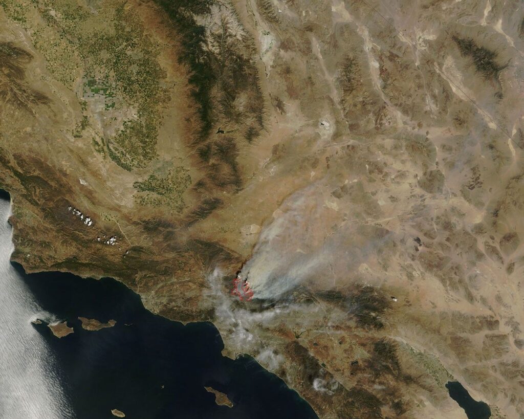
LOS ANGELES, Sept. 2 — A NASA satellite image released yesterday shows the Station Fire’s smoke extending northeast from the mountains above Los Angeles, a visible consequence of the blaze reaching well beyond the ground occupied by its flames.
Terra’s MODIS instrument acquired the image at about 11:45 a.m. local time on August 30. The red outlines mark unusually hot areas associated with fires. They are instrument detections, not a surveyed boundary around every burned acre.
The smoke plume and the outlines therefore answer different questions. The plume shows material being carried through the atmosphere; the red marks identify heat apparent to the sensor at the time of the pass. Neither is a street-level evacuation map.
NASA’s account places the marked hot areas west of Mount Wilson in this frame. Its separate MISR observations from August 30 describe smoke reaching high above the region and drifting eastward. These views record a particular stage of a changing incident, and should not be read as a continuous picture of the fire’s present position.
The MODIS image is credited to Jeff Schmaltz and the Rapid Response Team at NASA’s Goddard Space Flight Center. Keeping the acquisition time beside that credit lets readers distinguish a useful regional record from an immediate report of conditions outside their door.
Sources & further reading
Related Herald reporting
- Station Fire Leaves the Angeles Forest With a Long Recovery — Jennifer Dalton, 2009-10-25.
- Catalina’s Fire Scar Leaves a Long Recovery Beyond Avalon — Jennifer Dalton, 2007-11-12.
- Witch Fire Carries a Backcountry Emergency Into Rancho Bernardo — Jennifer Dalton, 2007-11-11.
- Old Fire Leaves a Burned Route From Valley to Mountain — Jennifer Dalton, 2003-11-23.
- Cedar Fire Crosses the Distance Between Forest and City — Jennifer Dalton, 2003-11-16.
- Thomas Fire Ends With a Second Disaster in Its Watershed — Jennifer Dalton, 2018-01-21.
- Camp Fire Search Revises the Toll as Paradise Faces Its Ruins — Jennifer Dalton, 2018-12-05.
- Woolsey Fire Leaves Homes and a Piece of the Movies to Rebuild — Jennifer Dalton, 2019-01-13.
- Bobcat Fire Burns a Route Across the San Gabriels — Jennifer Dalton, 2020-12-27.
- Palisades Fire Contained Without the Loss of a Home — Jennifer Dalton, 2021-05-27.
- Dixie Fire Burns Through Greenville as Smoke Spreads Across the West — Jennifer Dalton, 2021-08-08.
- McKinney Crews Turn to Repair After Fire Devastates Klamath River — Jennifer Dalton, 2022-08-30.
- Mosquito Fire Leaves Waterworks and Burned Homes in the Repair Account — Jennifer Dalton, 2022-10-24.
- Post Fire Leaves Hungry Valley Closed for a Different Kind of Recovery — Jennifer Dalton, 2024-07-04.
- Park Fire Leaves a 429,603-Acre Scar as Emergency Managers Count the Disruption — Jennifer Dalton, 2024-09-25.
- Eaton Fire Containment Leaves Altadena Facing a Long Recovery — Jennifer Dalton, 2025-02-01.
- Old Topanga Fire Tested Every Route Between the Canyons and the Coast — Gary Preston, 1993-11-14.
- Laguna Beach Reckons With a Fire That Reached the Houses — Gary Preston, 1993-11-14.
Join the conversation