

The Aeon Herald / HERALD ORIGINAL
Dixie Fire Burns Through Greenville as Smoke Spreads Across the West
Satellite views record the fire’s advance and a smoke plume stretching far beyond the destroyed mountain town.
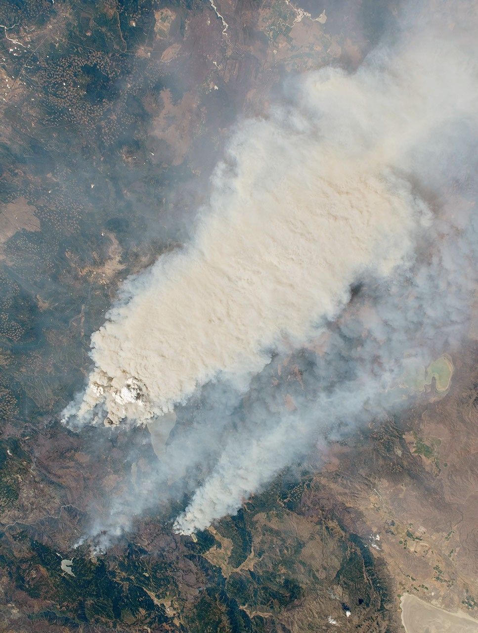
GREENVILLE, Aug. 8.—Homes and businesses have burned in Greenville as the Dixie Fire spreads through Plumas County. Evacuation orders have extended to other mountain communities. The blaze began July 13 and remains an active emergency.
NASA’s August 7 account gives an area above 432,000 acres as of August 6, following about 70,000 acres of growth in one day. It was then the third-largest California fire on record and the largest currently burning in the United States. These figures describe a moving perimeter, rather than a completed survey.
An astronaut photographed the smoke plume August 4. Landsat also recorded active fronts that day. The spacecraft views show both intense burning and smoke extending beyond the fire; they cannot establish whether a particular home survives beneath the plume.
Greenville’s destruction makes the acreage figure a community loss. Residents elsewhere under evacuation orders face the urgent question of leaving before roads become impassable. A final cause, completed building inventory and containment date are still beyond this account.
Sources & further reading
- California’s Dixie Fire Keeps on Growing — Kathryn Hansen / NASA Earth Observatory; August 7, 2021.
- California wildfire explodes in size, destroys historic town — Andrew Freedman / Axios; additional reporting by Rebecca Falconer and Jacob Knutson; August 5, 2021.
- Dixie Fire incident record — CAL FIRE; 2021 incident.
Related Herald reporting
- Palisades Fire Contained Without the Loss of a Home — Jennifer Dalton, 2021-05-27.
- Bobcat Fire Burns a Route Across the San Gabriels — Jennifer Dalton, 2020-12-27.
- McKinney Crews Turn to Repair After Fire Devastates Klamath River — Jennifer Dalton, 2022-08-30.
- Mosquito Fire Leaves Waterworks and Burned Homes in the Repair Account — Jennifer Dalton, 2022-10-24.
- Woolsey Fire Leaves Homes and a Piece of the Movies to Rebuild — Jennifer Dalton, 2019-01-13.
- Camp Fire Search Revises the Toll as Paradise Faces Its Ruins — Jennifer Dalton, 2018-12-05.
- Post Fire Leaves Hungry Valley Closed for a Different Kind of Recovery — Jennifer Dalton, 2024-07-04.
- Park Fire Leaves a 429,603-Acre Scar as Emergency Managers Count the Disruption — Jennifer Dalton, 2024-09-25.
- Eaton Fire Containment Leaves Altadena Facing a Long Recovery — Jennifer Dalton, 2025-02-01.
- Thomas Fire Ends With a Second Disaster in Its Watershed — Jennifer Dalton, 2018-01-21.
- Eaton Fire Recovery Reaches From Burned Lots to Classrooms — Jennifer Dalton, 2025-08-03.
- Palisades Fire Leaves a Neighborhood and Its Public Landscape to Rebuild — Jennifer Dalton, 2025-08-03.
- Station Fire Leaves the Angeles Forest With a Long Recovery — Jennifer Dalton, 2009-10-25.
- Station Fire’s Smoke Spreads Beyond the Flames in Satellite View — Andre Lawson, 2009-09-02.
- Catalina’s Fire Scar Leaves a Long Recovery Beyond Avalon — Jennifer Dalton, 2007-11-12.
- Witch Fire Carries a Backcountry Emergency Into Rancho Bernardo — Jennifer Dalton, 2007-11-11.
- Old Fire Leaves a Burned Route From Valley to Mountain — Jennifer Dalton, 2003-11-23.
- Cedar Fire Crosses the Distance Between Forest and City — Jennifer Dalton, 2003-11-16.
HERALD ORIGINAL
Join the conversation